GeoExtをMobile環境で使う
ネットでいろいろと探していると、本当にいろんなものがあります。
こんなことできたら良いなぁ?とか、こんなアイディアはどうだろう?なんて事を googleで調べてみると、
サービスとして提供されていたり、開発中だったりというのが、ほとんどです。
このGeoExtもmobileでは動かせるのかな?と調べたところ、ありましたね。
などに詳しくGXMもことが書かれています。
先人に感謝します。
jQuery使わなくても、ExtJSとGXMでmobile application開発できます。
ま、Openlayers-2.12のexamplesにもjquery mobileのexampleも出ているくらいですからね。
GXMってどんなもの?
開発環境をセットアップしただけなので、使いこなしていないので、さわりだけをちょこっと。
GXMは、
-
Sencha Touch
-
OpenLayers 2.11以上
で書かれたmobileで動く GeoExt JavaScript libraryです。
GeoExtと同様の使い方ができるようですが、まだversion 0.1で0.2開発中とのことで、これから本腰を入れて開発が進んでいくのでしょう。
サンプルですが、firefoxではうまく表示されないようですね。
サンプルみるときは、Google chromeを使ってくださいね。
-
A component that wraps an OpenLayers Map and acts as a Map component.
-
A button component that can be used to control OpenLayers controls.
-
A list component that can be used to show a list of OpenLayers Layer objects.
-
A list component that can be used to show a list of OpenLayers features objects.
-
A popup component that can be used to show details about an OpenLayers features.
-
A renderer that can be used to generated embedable components of the visual appearance of OpenLayers Features.
-
A layerstore that wraps around instances of OpenLayers layers
-
A model that maps OpenLayers layer instances to be used inside of stores
などなど、examplesがあります。
ちょこっと中身を見てみる
使い方は、GeoExt2と同じように使えるみたいですので、ちょいとサンプルをみてみましょう。
GeoExt1.1とは、使い方が大きく変わります。
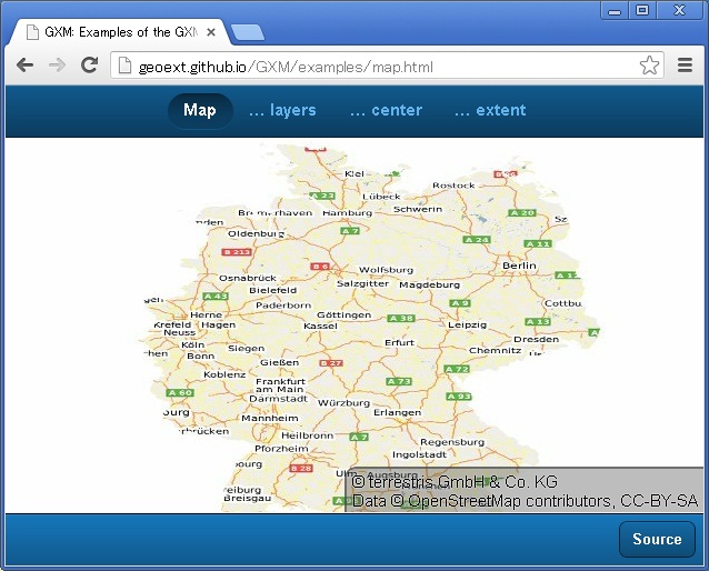
では、exampleのmap.htmlを
<!DOCTYPE html>
<html>
    <head>
        <meta http-equiv="Content-Type" content="text/html; charset=utf-8">

        <title>GXM: Examples of the GXM.Map-class</title>

        <meta name="viewport" content="width=device-width, user-scalable=no, initial-scale=1.0, maximum-scale=1.0">
        <meta name="apple-mobile-web-app-capable" content="yes">

        <!-- The CSS of Sencha Touch and GXM -->
        <link rel="stylesheet" href="http://cdn.sencha.io/touch/sencha-touch-2.0.1/resources/css/sencha-touch.css" type="text/css">
        <link rel="stylesheet" href="http://openlayers.org/api/2.11/theme/default/style.tidy.css" type="text/css">
        <link rel="stylesheet" href="../resources/css/gxm.css" type="text/css">
        <link rel="stylesheet" href="./examples.css" type="text/css">

        <!-- Load Sencha Touch -->
        <script type="text/javascript" src="http://cdn.sencha.io/touch/sencha-touch-2.0.1/sencha-touch-all.js"></script>
        <!-- Load OpenLayers -->
        <!-- You should definitely consider using a custom single-file version of OpenLayers -->
        <script type="text/javascript" src="http://openlayers.org/api/2.11/OpenLayers.js"></script>

        <!-- This file loads all relevant files -->
        <script type="text/javascript" src="../src/GXM.loader.js"></script>
        <script type="text/javascript" src="./example-utility.js"></script>
        <script type="text/javascript" src="./map.js"></script>
    </head>
    <body>
    </body>
</html>
な感じで、senchaとOpenLayersとGXMを読み込みます。
sourceはGXM・GitHubから入手してくださいね。
次に、map.jsを見てみましょう。
Ext.require([ 'GXM.Map' ]); Ext.setup({ viewport : { autoMaximize : true }, onReady : function() { // OpenLayers specific setup var map = new OpenLayers.Map({ controls : [ new OpenLayers.Control.TouchNavigation({ dragPanOptions : { interval : 100, enableKinetic : true } }), new OpenLayers.Control.Attribution(), new OpenLayers.Control.Navigation() ] }); var layerOwsOsmTerrestris = new OpenLayers.Layer.WMS('terrestris', 'http://ows.terrestris.de/osm-basemap/service', { layers : 'OSM-WMS-Deutschland' }, { singleTile : false, attribution : '© terrestris GmbH & Co. KG<br>Data © OpenStreetMap contributors, CC-BY-SA' }); map.addLayers([layerOwsOsmTerrestris]); // Helper method to get a tab card by index var getCard = function(idx) { var card; // Case GXM.Map with OpenLayers.Map if(idx === 0) { card = { xtype : 'gxm_map', // A reference to an OpenLayers.Map map : map, mapCenter : [10.15,51.34], mapZoom: 6, title : 'Map', sourceCode: example.utility.getExampleCode('mappanel-simple') }; // Case GXM.Map with OpenLayers.Layer } else if(idx === 1) { card = { xtype : 'gxm_map', // A reference to an OpenLayers.Layer layers : [layerOwsOsmTerrestris.clone()], mapCenter : [10.15,51.34], mapZoom: 6, controls: [ new OpenLayers.Control.TouchNavigation({ dragPanOptions : { interval : 100, enableKinetic : true } }), new OpenLayers.Control.Attribution(), new OpenLayers.Control.Navigation() ], title : '… layers', sourceCode: example.utility.getExampleCode('mappanel-layers') }; // Case GXM.Map with OpenLayers.Map and mapCenter and mapZoom } else if(idx === 2) { card = { xtype: 'gxm_map', layers : [layerOwsOsmTerrestris.clone()], // Pass as array, as string or OpenLayers.LonLat-instance mapCenter : [7.1, 50.74], // Pass as an integer mapZoom: 12, controls: [ new OpenLayers.Control.TouchNavigation({ dragPanOptions : { interval : 100, enableKinetic : true } }), new OpenLayers.Control.Attribution(), new OpenLayers.Control.Navigation() ], title : '… center', sourceCode: example.utility.getExampleCode('mappanel-center') }; // Case GXM.Map with OpenLayers.Map and mapExtent } else if(idx === 3) { card = { xtype : 'gxm_map', layers : [layerOwsOsmTerrestris.clone()], // Pass as array, as string or OpenLayers.Bounds-instance mapExtent : '7,51,8,52', controls: [ new OpenLayers.Control.TouchNavigation({ dragPanOptions : { interval : 100, enableKinetic : true } }), new OpenLayers.Control.Attribution(), new OpenLayers.Control.Navigation() ], title : '… extent', sourceCode: example.utility.getExampleCode('mappanel-extent') }; } return card; }; // Create viewport and also add a button showing a snipped of sourcecode in a // floating Ext.Panel. See example-utility.js for the shown code. var viewport = Ext.create('Ext.TabPanel', { fullscreen : true, ui : 'dark', tabBar : { docked : 'top', layout : { pack : 'center' } }, items : [getCard(0), getCard(1), getCard(2), getCard(3), { xtype : 'toolbar', ui : 'dark', items : [ {xtype : 'spacer'}, { xtype : 'button', text : 'Source', handler : function() { Ext.create('Ext.Panel', { fullscreen: false, draggable : false, modal : true, height: '40%', width: '40%', centered : false, styleHtmlContent : true, scrollable : true, hideOnMaskTap: true, html : viewport.getActiveItem().config.sourceCode }).showBy(this); } }], docked : 'bottom' }] }); } });
まずは、
Ext.require([ 'GXM.Map' ]);
で、GXMのcoreのであるGXM.Mapを読み込みます。
次に、
Ext.setup({
    viewport : {
        autoMaximize : true
    },
    onReady : function() {....
     ....
     ....
}
な感じで、viewportを設定して、onReadt : function()….でpanelに描画します。
xtype : 'gxm_map'がGXMで定義されているmapのtypeになるようです。
なんとなく、読み込むべきscriptなどは違いますが、GeoExt1.1と使用方法は違わないようですね。
tabやpanelやtoolbarについては、sourceを見て検討してください。
mapのwmsの部分を電子国土やOpenStreetMapに置き換えれば、なんとなくアプリを作れそうですね。
でどうよ?
GeoExt2をそのまま使えそうなので、良いのではないでしょうか?
GeoExt2のコードを若干修正すれば、十分mobile環境で活用できますよね。HTML5+JavaScriptでnative applicationの開発もだきるか、今後検証してみます。
いや~~、似たようなこと考えた人いるんですよね。
OpenLayer 3も出たしなぁ~。 α版なので、まだまだですが、興味を引く機能が追加されているんですよね。
Openlayer 3 examplesを見てくださいね。
いろいろなものがあって悩みますな。


最近のコメント